News & Alerts
Flood Warning
North Bay District
Lake Temagami/Sturgeon River/Lake Nipissing/French River
Thursday, May 09, 2024
1:30pm
The Ministry of Natural Resources and Forestry – North Bay District is advising the residents in the Lake Temagami/Sturgeon River/Lake Nipissing/Upper French River areas that a Flood Warning remains in effect until 4pm Thursday, May 16, 2024 unless it’s updated or replaced by this time.
Residents in these areas should keep a close watch on conditions and exercise caution around shorelines and low-lying areas. Please alert and monitor any children under your care to possible dangers and supervise their activities.
The ministry is closely monitoring the weather and developing watershed conditions. Further updates will be issued as appropriate.
TECHNICAL INFORMATION
Description of Weather System
With the arrival of a ridge of high pressure, the weather forecast for the Northeast Region is calling for minimal rainfall into next week with less than 10mm expected to fall locally by Monday.
Description of Current Conditions
Water levels and flows continue to be elevated from Lake Temagami down to the Upper French River. These conditions continue after the watershed received significant rainfall/runoff after several weather systems over the past month. With minimal rainfall forecast over the next five days, levels are expected to be sustained and then begin a gradual decline, bringing a slow decrease to water levels and flows throughout the
watershed over the coming days. If precipitation is received, this could stall the decrease in water levels and flows. If a significant weather system is received water levels and flows could begin to rise once again. A close watch of local weather forecasts, special weather statements and warnings continues to be recommended.
Lake Temagami water levels are high and continue to be within the flood allowance. The current lake level is 294.04m.
Sturgeon River water levels are currently within normal operating ranges.
Lake Nipissing water levels are high, yesterday’s average level on the lake was measured at 196.19m which is below the ‘non-damage’ level of 196.22m. Flooding continues along the shoreline of Lake Nipissing.
The Upper French River area continues to see high water levels. The current level (as of May 8) at Wolseley Bay is 188.31m which has exceeded the current flood limit. The current level (as of May 8) at Dry Pine Bay is 182.82m which is just below the current flood limit. Residents along the river continue to see impacts from high water levels.
Municipalities, residents and visitors, especially those in low-lying areas and along shorelines, are encouraged to monitor conditions and prepare accordingly. Shorelines and banks adjacent to waterbodies are very slippery and unstable at this time and when combined with cold, fast flowing water, pose a serious hazard.
Structures such as homes, boat houses and docks could be at risk of flooding if located near lake/river level. Residents in these areas are encouraged to monitor conditions and prepare accordingly.
DEFINITIONS
· WATERSHED CONDITIONS STATEMENT – WATER SAFETY: indicates that high flows, melting ice or other factors could be dangerous for such users as boaters, anglers and swimmers but flooding is not expected.
· WATERSHED CONDITIONS STATEMENT – FLOOD OUTLOOK: gives early notice of the potential for flooding based on weather forecasts calling for heavy rain, snow melt, high winds or other conditions
· SHORELINE CONDITIONS STATEMENT – WATER SAFETY: indicates that along the Great Lakes shorelines high water, melting ice or other factors could be dangerous but flooding is not expected.
· SHORELINE CONDITIONS STATEMENT – FLOOD OUTLOOK: gives early notice of the potential for flooding along the Great Lakes shorelines based on weather and lake conditions, and water safety information.
· FLOOD WATCH: potential for flooding exists within specific watercourses and municipalities
· FLOOD WARNING: flooding is imminent or occurring within specific watercourses and municipalities.
LEARN MORE
· Surface Water Monitoring Centre public webpage www.ontario.ca/page/surface-water-monitoring-centre · Environment Canada bulletins: www. weather.gc.ca
· A close watch on local conditions and weather forecasts from Environment Canada is recommended.
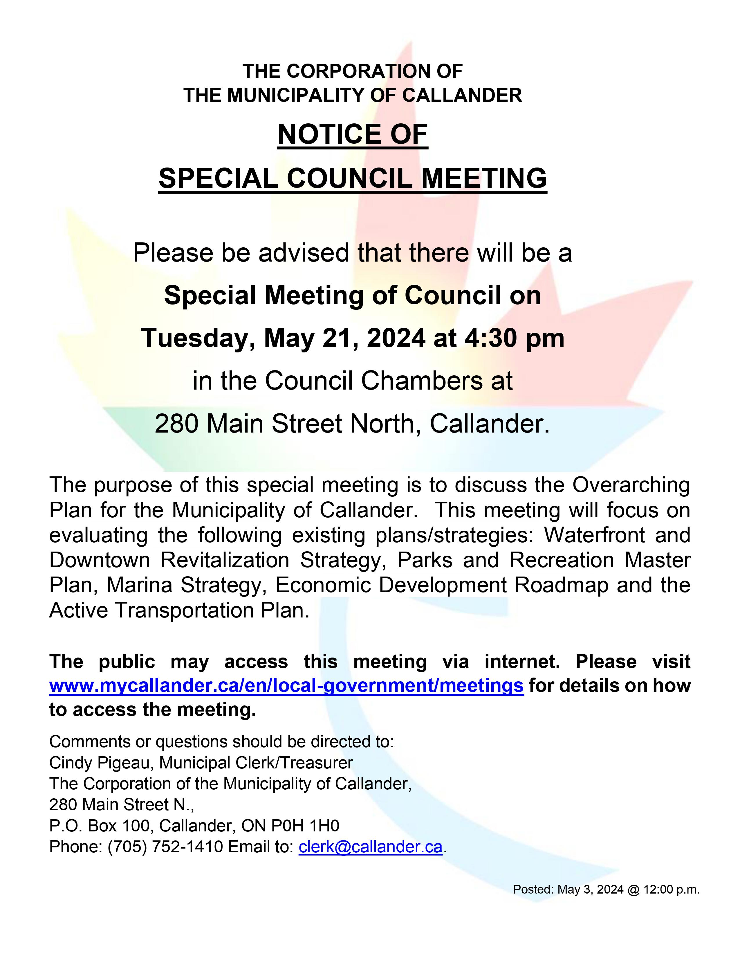
Please be advised that the Special Meeting of Council scheduled for Tuesday, May 21, 2024 at 4:30 pm has been CANCELLED.
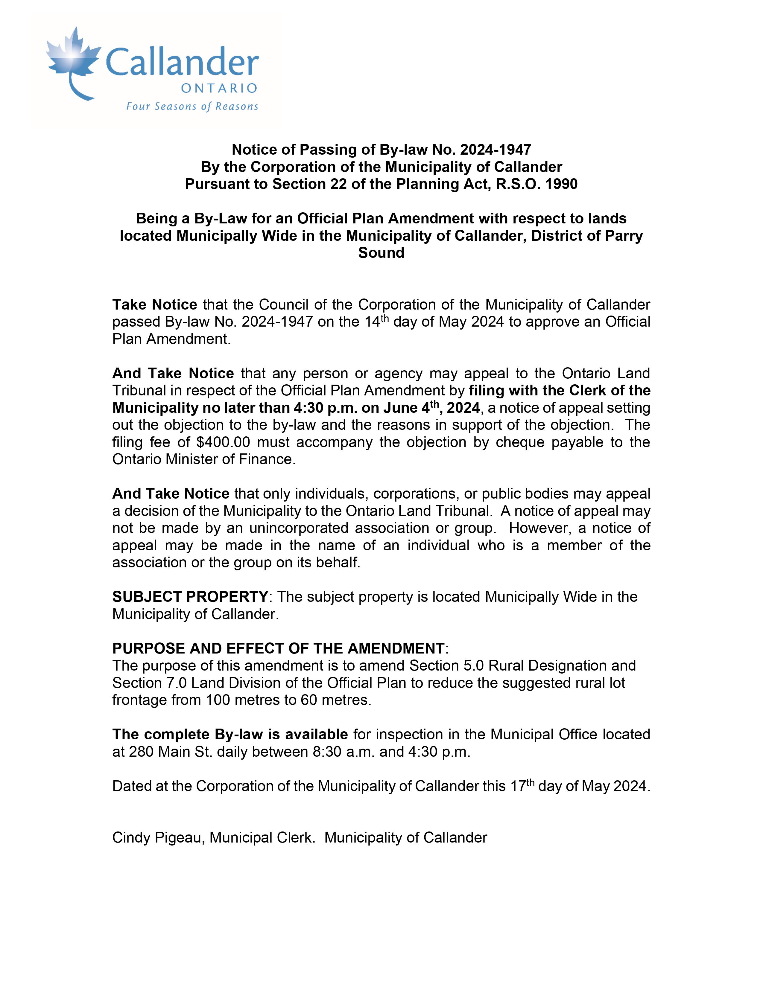
PUBLIC NOTICE Passing of By-Law 2024-1947
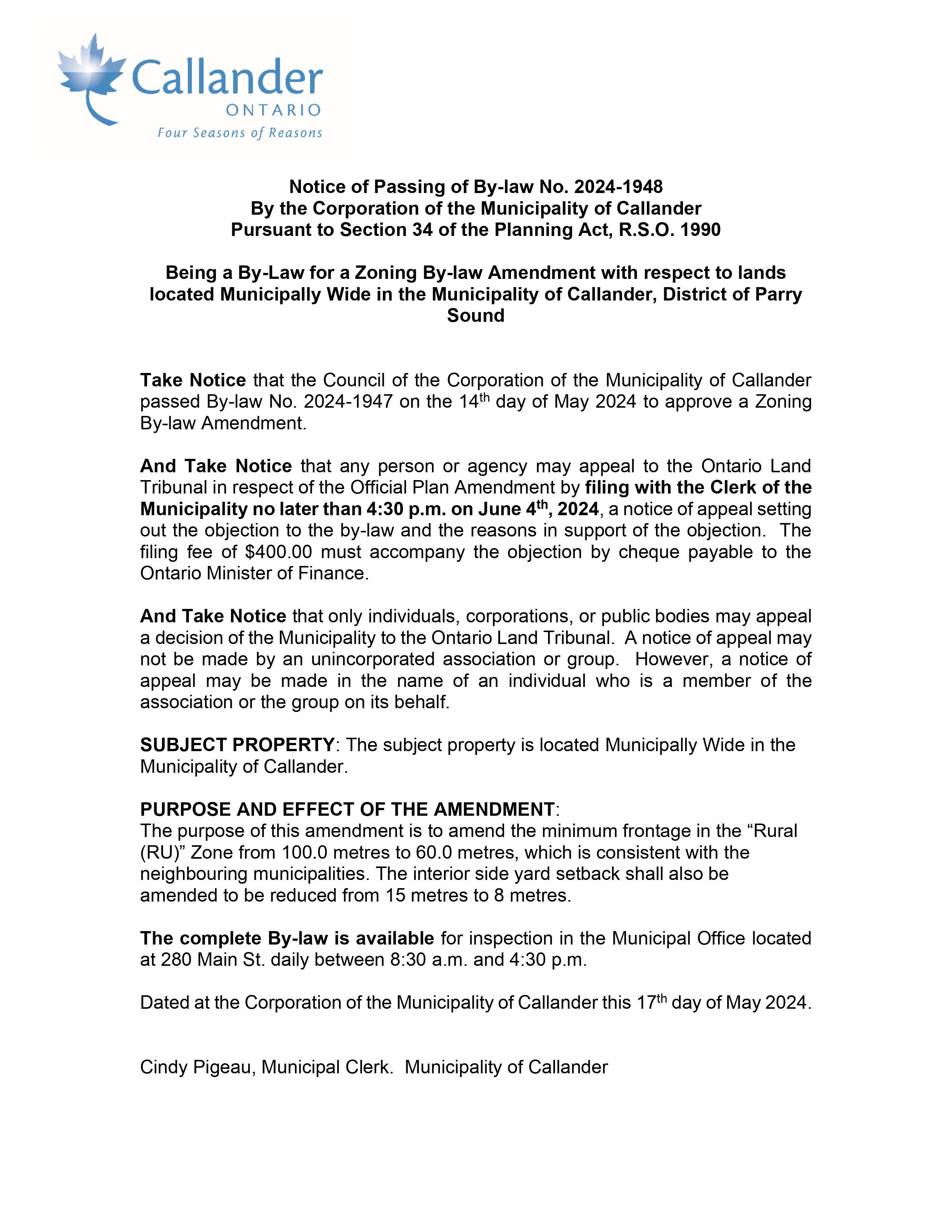
PUBLIC NOTICE Passing of By-Law 2024-1948